Robert F. Barrett Collection
Pages
-
-
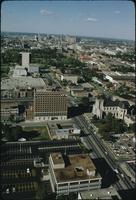
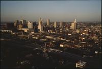
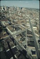
View from Broadway Boulevard
-
Aerial view of Kansas City from above Broadway Boulevard looking north. The headquarters for Veterans for Foreign Wars and Our Lady of Perpetual Help Parish are on the left along Broadway. Downtown Kansas City is visible in the distance., September 1974, Digitizing agency: University of Missouri--Kansas City. Library. Dr. Kenneth J. LaBudde Special Collections., "Bob Barrett" is printed on slide mount.
-
-
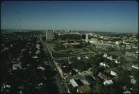
View from Broadway Boulevard
-
Aerial view of Kansas City from above Broadway Boulevard looking north. Houses are along the left side and foreground. Two large radio antennas are on the left and right side. Downtown Kansas City is visible in the distance., September 1974, Digitizing agency: University of Missouri--Kansas City. Library. Dr. Kenneth J. LaBudde Special Collections., Slide mount is captioned "BMA Tower + Skyline K.C.M.O." "Bob Barrett" printed on slide mount.
-
-
View from Broadway Boulevard
-
Aerial view of Kansas City from above Broadway Boulevard looking north. The headquarters for Veterans for Foreign Wars and Our Lady of Perpetual Help Parish are on the left along Broadway. Downtown Kansas City is visible in the distance., September 1974, Digitizing agency: University of Missouri--Kansas City. Library. Dr. Kenneth J. LaBudde Special Collections., "Copyright '84 / Bob Barrett" is printed on slide mount.
-
-
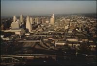
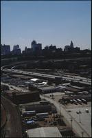
View from Highway 35
-
Aerial view of Kansas City above Interstates 35 and 670 looking east. Skyscrapers, parking lots, and downtown Kansas City are visible across from the highway The sun is setting and casting large shadows on the buildings., 1984, Digitizing agency: University of Missouri--Kansas City. Library. Dr. Kenneth J. LaBudde Special Collections., "Copyright '84 / Bob Barrett" is printed on slide mount.
-
-
View from Highway 71
-
Aerial view of Kansas City above highway 71 looking west. Skyscrapers, parking lots, and downtown Kansas City are visible across from highway 71. Warehouses and factories are on the other side of the highway. The Missouri River is on the right., March 1986, Digitizing agency: University of Missouri--Kansas City. Library. Dr. Kenneth J. LaBudde Special Collections., "LXXXVI Bob Barrett" is printed on slide mount.
-
-
View from Highway 71
-
Aerial view of Kansas City above highway 71 looking west. Skyscrapers, parking lots, and downtown Kansas City are visible across from highway 71. Warehouses and factories are on the other side of the highway. The Missouri River is on the right., March 1986, Digitizing agency: University of Missouri--Kansas City. Library. Dr. Kenneth J. LaBudde Special Collections., "LXXXVI Bob Barrett" is printed on slide mount.
-

-
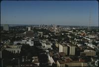
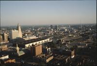
View from Main Street
-
Aerial view of Kansas City from above Main Street looking north. The Hotel Netherlands is on the right side of the street along with several office buildings. Houses are on the far right and left. A large radio antenna is visible in the distance along with downtown Kansas City., September 1974, Digitizing agency: University of Missouri--Kansas City. Library. Dr. Kenneth J. LaBudde Special Collections., Slide mount is captioned "Main St. Looking N K.C.MO." "Bob Barrett" is printed on slide mount.
-
-
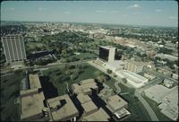
View from Penn Valley
-
Aerial view of Kansas City from above Penn Valley. The One Park Place building is on the left and the Penn Tower is on the right. Penn Valley Park is between the buildings. Downtown Kansas City is visible in the distance., September 1974, Digitizing agency: University of Missouri--Kansas City. Library. Dr. Kenneth J. LaBudde Special Collections., Slide mount is captioned "BMA Skyline Penn Tower Penn Valley Comm-College." "Bob Barrett" is printed on slide mount.
-
-
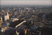
View from Southwest Boulevard
-
Aerial view of Kansas City above Southwest Boulevard looking northeast. Skyscrapers and downtown Kansas City are visible on the left. Dozens of warehouses and office buildings are spread throughout the city., September 1974, Digitizing agency: University of Missouri--Kansas City. Library. Dr. Kenneth J. LaBudde Special Collections., Slide mount is captioned "K.C.MO." "Bob Barrett" is printed on slide mount.
-

-
View from Westport neighborhood
-
Aerial view of Kansas City from the Westport neighborhood looking north. Several parking lots are in the foreground next to warehouses and office buildings. Skyscrapers and downtown Kansas City are visible in the distance. A large radio antenna is visible in the center., September 1974, Digitizing agency: University of Missouri--Kansas City. Library. Dr. Kenneth J. LaBudde Special Collections., Slide mount is captioned "File main street USA." "Bob Barrett" printed on slide mount.
-
-
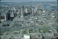
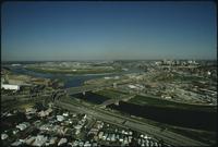
View from the Convention Center
-
Aerial view of Kansas City looking southeast. Interstate 670 is passing under several road bridges and intersects with Interstate 35 on the right. The Convention Center, Municipal Auditorium, and Kansas City Power and Light Building are on the left. There are office buildings and houses spread out across the top of the photo., 1984, Digitizing agency: University of Missouri--Kansas City. Library. Dr. Kenneth J. LaBudde Special Collections., "Copyright '84 / Bob Barrett" is printed on slide mount.
-

-
View from the Convention Center
-
Aerial view of Kansas City looking southeast. Interstate 670 is passing under several road bridges and intersects with Interstate 35 on the right. The Convention Center, Municipal Auditorium, and Kansas City Power and Light Building are on the left. There are office buildings and houses spread out across the top of the photo., 1984, Digitizing agency: University of Missouri--Kansas City. Library. Dr. Kenneth J. LaBudde Special Collections., "Copyright '84 / Bob Barrett" is printed on slide mount.
-
-
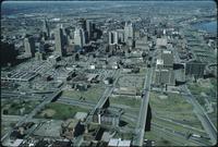
View from the Convention Center
-
Aerial view of Kansas City above the Convention Center looking southeast. Interstate 670 is passing under several road bridges and intersects with Interstate 35 on the right. The Convention center has a dark, flat roof. The Municipal Auditorium is to the left of the center. The Kansas City Power and Light Company Building is to the left of the auditorium. There are office buildings and houses spread out across the top of the photo., 1984, Digitizing agency: University of Missouri--Kansas City. Library. Dr. Kenneth J. LaBudde Special Collections., "Copyright '84 / Bob Barrett" is printed on slide mount.
-
-
View from the Convention Center
-
Aerial view of Kansas City looking southeast. Interstate 670 is passing under several road bridges and intersects with Interstate 35 on the right. The Convention Center, Municipal Auditorium, and Kansas City Power and Light Building are on the left. There are office buildings and houses spread out across the top of the photo., 1984, Digitizing agency: University of Missouri--Kansas City. Library. Dr. Kenneth J. LaBudde Special Collections., "Copyright '84 / Bob Barrett" is printed on slide mount.
-
-
View from the Convention Center
-
Aerial view of Kansas City above the Convention Center looking southeast. Interstate 670 is passing under several road bridges. The Convention center has a dark, flat roof. The Municipal Auditorium is to the left of the center. The Kansas City Power and Light Company Building is to the left of the auditorium. There are office buildings and houses spread out across the top of the photo., 1984, Digitizing agency: University of Missouri--Kansas City. Library. Dr. Kenneth J. LaBudde Special Collections., "Copyright '84 / Bob Barrett" is printed on slide mount.
-
-
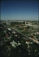
View of Penn Valley area
-
Aerial view of the BMA building, also known as One Park Place, and Penn Valley Community College in the midtown Kansas City area. There are houses along the bottom. Skyscrapers and downtown Kansas City are in the distance. Broadway Boulevard runs diagonally from lower right to upper left., September 1974, Digitizing agency: University of Missouri--Kansas City. Library. Dr. Kenneth J. LaBudde Special Collections., Slide mount is captioned "Penn Valley Comm. College BMA bldg."
-
-
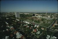
View of Penn Valley area
-
Aerial view of the BMA building, also known as One Park Place, and Penn Valley Community College in the midtown Kansas City area. There are houses along the bottom. Skyscrapers and downtown Kansas City are in the distance. A large radio antenna is on the right. Broadway Boulevard runs diagonally from lower right to upper left., September 1974, Digitizing agency: University of Missouri--Kansas City. Library. Dr. Kenneth J. LaBudde Special Collections., "Bob Barrett" is printed on slide mount.
-
-
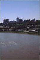
View of the Kansas City skyline
-
Aerial view of the Kansas City skyline and the West Bottoms area. Factories and warehouses are on both sides of Main Street. Skyscrapers and downtown Kansas City is visible in the distance. There is one road bridge over the Missouri River on the right., 1986, Digitizing agency: University of Missouri--Kansas City. Library. Dr. Kenneth J. LaBudde Special Collections., Slide mount is captioned "Kansas City:Aerials,Skyline." "Copyright '85 / Bob Barrett" printed on slide mount.
-
-
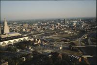
View of the West Bottoms
-
Aerial view of the West Bottoms area of Kansas City where the Kansas River and Missouri Rivers converge. Interstates 70 and 35 cross the Kansas River heading toward downtown Kansas City in the distance on the right. There are houses below the Kansas River and warehouses in the West Bottoms area. Skyscrapers are visible in the distance., September 1974, Digitizing agency: University of Missouri--Kansas City. Library. Dr. Kenneth J. LaBudde Special Collections., "Bob Barrett" is printed on slide mount.
-

-
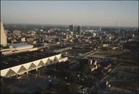
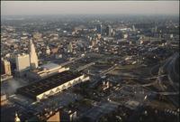
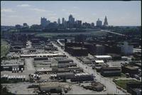
Warehouses and parking lots in front of Kansas City
-
Aerial view of warehouses and parking lots in front of Kansas City. Skyscrapers and downtown Kansas City are visible in the distance Cars are parked in each of the lots., June 1986, Digitizing agency: University of Missouri--Kansas City. Library. Dr. Kenneth J. LaBudde Special Collections., Slide mount is captioned "Kansas City:Aerials Skyline." "LXXXVI Bob Barrett" is printed on slide mount.
-

-
West Bottoms of Kansas City
-
Aerial view looking southeast over Interstate 70 in the West Bottoms area. Skyscrapers and downtown Kansas City are visible in the distance. There are warehouses and factories near the highway. The Missouri River is in the foreground., 1986, Digitizing agency: University of Missouri--Kansas City. Library. Dr. Kenneth J. LaBudde Special Collections., Slide mount is captioned "Kansas City:Aerials,Skyline." "Copyright '85 / Bob Barrett" printed on slide mount.
-
-
West Bottoms of Kansas City
-
Aerial view looking east over Interstate 70 in the West Bottoms area. Skyscrapers and downtown Kansas City are visible in the distance. There are warehouses and factories on both sides of the highway. Railroad tracks are on the left., 1986, Digitizing agency: University of Missouri--Kansas City. Library. Dr. Kenneth J. LaBudde Special Collections., Slide mount is captioned "Kansas City:Aerials,Skyline." "Copyright '85 / Bob Barrett" printed on slide mount.
-
-
West Bottoms of Kansas City
-
Aerial view looking southeast over the Missouri River in the West Bottoms area. Skyscrapers and downtown Kansas City are visible in the distance. There are warehouses and factories near Interstate 70. The river is in the foreground., 1986, Digitizing agency: University of Missouri--Kansas City. Library. Dr. Kenneth J. LaBudde Special Collections., Slide mount is captioned "Kansas City:Aerials,Skyline." "Copyright '85 / Bob Barrett" printed on slide mount.
-

-
West Bottoms of Kansas City
-
Aerial view looking east over Interstate 70 in the West Bottoms area. Skyscrapers and downtown Kansas City are visible in the distance. There are warehouses and factories on both sides of the highway., 1986, Digitizing agency: University of Missouri--Kansas City. Library. Dr. Kenneth J. LaBudde Special Collections., Slide mount is captioned "Kansas City:Aerials,Skyline." "Copyright '85 / Bob Barrett" printed on slide mount.
Pages