Robert F. Barrett Collection
Pages
-
-
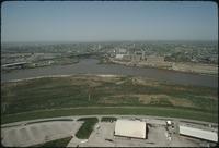
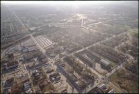
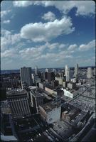
Aerial view above Wheeler Airport
-
Aerial view above Wheeler Airport in Kansas City, Missouri, overlooking the confluence of the Missouri and Kansas Rivers. A road bridge is crossing the Kansas River. Several small planes are parked below., May 1975, Digitizing agency: University of Missouri--Kansas City. Library. Dr. Kenneth J. LaBudde Special Collections., Slide mount is captioned "Kansas City Aerials "Historical Significance?" Helicopter/ May 1975." "Bob Barrett" is also printed on slide mount.
-
-
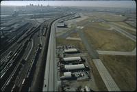
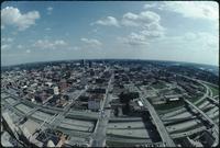
Aerial view above Wheeler Airport
-
Aerial view above Wheeler Airport in Kansas City, Missouri. Two airport runways are on the right next to several terminal buildings. Trains are moving along a network of railroad tracks on the left. Skyscrapers and downtown Kansas City are visible in the distance on the other side of the Missouri River., February 1, 1974, Digitizing agency: University of Missouri--Kansas City. Library. Dr. Kenneth J. LaBudde Special Collections., Slide mount is captioned "Kansas City Aerials "Historical Significance?" Helicopter/ May 1975." "Bob Barrett" is also printed on slide mount.
-
-
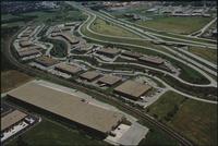
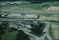
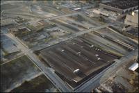
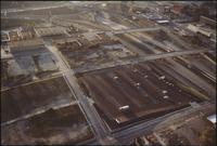
Aerial view of Brookhollow Industrial Park
-
Aerial view of warehouses and Interstate 35 at Brookhollow Industrial Park in Shawnee Mission, Kansas., 1986, Digitizing agency: University of Missouri--Kansas City. Library. Dr. Kenneth J. LaBudde Special Collections., Slide mount is captioned "Kansas City:Aerials Brookhollow Industrial Park Overland Park, Ks." "Copyright '86 / Bob Barrett" is printed on slide mount.
-
-
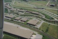
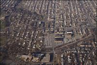
Aerial view of Brush Creek
-
Aerial view of the Brush Creek area in Kansas City. The Menorah Medical Center is in the center between Rockhill Road and Volker Boulevard. Parking lots and buildings for the University of Missouri-Kansas City are on the left. Brush Creek passes through the trees behind Menorah. The Nelson-Atkins Museum of Art is in the upper center at the edge of a long green lawn. The Country Club Plaza region is further up behind the Nelson lawn. There are houses spread throughout the area., December 22, 1984, Digitizing agency: University of Missouri--Kansas City. Library. Dr. Kenneth J. LaBudde Special Collections., "Copyright '84 / Bob Barrett" is printed on slide mount.
-
-
Aerial view of Brush Creek
-
Aerial view of the Brush Creek area in Kansas City. The Menorah Medical Center is in the bottom center between Rockhill Road and Volker Boulevard. Parking lots and buildings for University of Missouri-Kansas City are on the left. Brush Creek passes through the trees halfway up the photo. The Nelson-Atkins Museum of Art is in the center at the edge of a long green lawn. Skyscrapers and downtown Kansas City are in the distance., December 22, 1984, Digitizing agency: University of Missouri--Kansas City. Library. Dr. Kenneth J. LaBudde Special Collections., "Copyright '84 / Bob Barrett" is printed on slide mount.
-
-
Aerial view of Brush Creek
-
Aerial view of the Brush Creek area. The Medical Menorah Center is on the bottom left in between Rockhill Road and Volker Boulevard. Brush Creek passes through the trees next to Volker. There are parking lots surrounding the University of Missouri-Kansas City building for KCUR radio station. There are houses throughout the area., December 22, 1984, Digitizing agency: University of Missouri--Kansas City. Library. Dr. Kenneth J. LaBudde Special Collections., "Copyright '84 / Bob Barrett" is printed on slide mount.
-
-
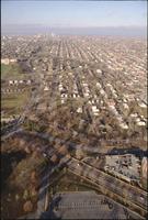
Aerial view of Brush Creek
-
Aerial view of Rockhill Road and Volker Boulevard in Kansas City. The Medical Menorah Center is on the right between both roads. Parking lots for the University of Missouri-Kansas City are at the bottom. Brush Creek passes along next to Volker. The Rockhill and Manheim neighborhoods are in the distance, along with skyscrapers and downtown Kansas City., December 22, 1984, Digitizing agency: University of Missouri--Kansas City. Library. Dr. Kenneth J. LaBudde Special Collections., "Copyright '84 / Bob Barrett" is printed on slide mount.
-
-
Aerial view of Brush Creek
-
Aerial view of the Brush Creek area in Kansas City. The corner of Emanuel Cleaver II Boulevard and Troost Avenue is in the center. There are parking lots, houses, and apartment buildings around the area. The Menorah Medical Center and University of Missouri-Kansas City are in the distance., December 22, 1984, Digitizing agency: University of Missouri--Kansas City. Library. Dr. Kenneth J. LaBudde Special Collections., "Copyright '84 / Bob Barrett" is printed on slide mount.
-
-
Aerial view of Brush Creek
-
Aerial view of the Brush Creek area in Kansas City. The Menorah Medical Center is at the bottom left of the photo next to Volker Boulevard. Brush Creek is to the right of Volker. The Nelson-Atkins Museum of Art is near the top of the photo at the edge of a long green lawn. There are parking lots and houses throughout the area., December 22, 1984, Digitizing agency: University of Missouri--Kansas City. Library. Dr. Kenneth J. LaBudde Special Collections., "Copyright '84 / Bob Barrett" is printed on slide mount.
-
-
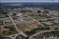
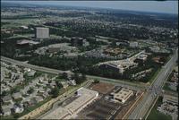
Aerial view of College Boulevard
-
Aerial view of buildings under construction along College Boulevard in Overland Park, Kansas. Several lots are empty and are covered in dirt. There are office buildings, warehouses, and parking lots throughout the area., 1986, Digitizing agency: University of Missouri--Kansas City. Library. Dr. Kenneth J. LaBudde Special Collections., Slide mount is captioned "Kansas City:Aerials College Blvd. area Overland Park, Ks." "Copyright '86 / Bob Barrett" is printed on slide mount.
-
-
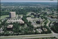
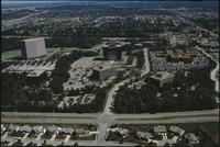
Aerial view of Corporate Woods Office Park
-
Aerial view of Corporate Woods Office Park in Overland Park, Kansas. There are several large office buildings and parking lots. There are neighborhoods of houses along winding roads in the distance., 1986, Digitizing agency: University of Missouri--Kansas City. Library. Dr. Kenneth J. LaBudde Special Collections., Slide mount is captioned "Kansas City:Aerials Corporate Woods Office Park Overland Park, Ks." "Copyright '86 / Bob Barrett" is printed on slide mount.
-
-
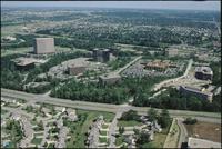
Aerial view of Corporate Woods Office Park
-
Aerial view of Corporate Woods Office Park in Overland Park, Kansas. Several large office buildings and parking lots are along the intersection of College Park and Antioch Road. There are neighborhoods of houses along winding roads on the left and in the distance., 1986, Digitizing agency: University of Missouri--Kansas City. Library. Dr. Kenneth J. LaBudde Special Collections., Slide mount is captioned "Kansas City:Aerials Corporate Woods Office Park Overland Park, Ks." "Copyright '86 / Bob Barrett" is printed on slide mount.
-
-
Aerial view of Corporate Woods Office Park
-
Aerial view of Corporate Woods Office Park in Overland Park, Kansas. There are several large office buildings and parking lots. There are neighborhoods of houses along winding roads in the distance., 1986, Digitizing agency: University of Missouri--Kansas City. Library. Dr. Kenneth J. LaBudde Special Collections., Slide mount is captioned "Kansas City:Aerials Corporate Woods Office Park Overland Park, Ks." "Copyright '86 / Bob Barrett" is printed on slide mount.
-
-
Aerial view of Executive Hills
-
Aerial view of Executive Hills office park in Overland Park along Interstate 435. Houses are being built on the other side of the highway. Several office buildings and parking lots are below the highway., June 1986, Digitizing agency: University of Missouri--Kansas City. Library. Dr. Kenneth J. LaBudde Special Collections., Slide mount is captioned "Kansas City:Aerials Various scenes, KC area." "LXXXVI Bob Barrett" is printed on slide mount.
-
-
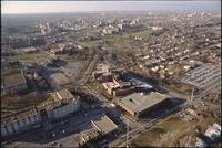
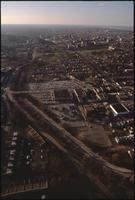
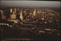
Aerial view of Kansas City
-
Aerial view of Kansas City above the intersection of Interstates 35 and 670 looking east. Downtown is on the left, including the Convention Center, Municipal Auditorium, and Kansas City Power and Light Building. There are office buildings and houses spread to the right of the photo., 1984, Digitizing agency: University of Missouri--Kansas City. Library. Dr. Kenneth J. LaBudde Special Collections., "Copyright '84 / Bob Barrett" is printed on slide mount.
-
-
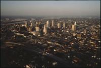
Aerial view of Kansas City
-
Aerial view of Kansas City above Interstate 35 looking northeast. Skyscrapers, parking lots, and downtown Kansas City are visible in the center. There are office buildings and houses spread to the right. The sun is setting and casting shadows on the buildings., 1984, Digitizing agency: University of Missouri--Kansas City. Library. Dr. Kenneth J. LaBudde Special Collections., "Copyright '84 / Bob Barrett" is printed on slide mount.
-
-
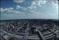
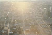
Aerial view of Kansas City
-
Aerial view of Kansas City looking south from the Power & Light district. Interstate 670 passes underneath several road bridges. Office buildings and warehouses are on the other side of the highway., June 1983, Digitizing agency: University of Missouri--Kansas City. Library. Dr. Kenneth J. LaBudde Special Collections., Slide mount is captioned "Kansas City, Mo. (Historical) View to the South--June '83 atop power & Light Bldg."
-
-
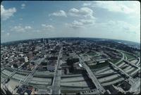
Aerial view of Kansas City
-
Aerial view of Kansas City looking northeast from atop the Power & Light building. Several parking lots are in the foreground. Cars are driving along the roads. There are dozens of skyscrapers and office buildings. The Missouri River is visible in the distance., June 1983, Digitizing agency: University of Missouri--Kansas City. Library. Dr. Kenneth J. LaBudde Special Collections., Slide mount is captioned "Kansas City, Mo. (Historical) View to the South--June '83 atop power & Light Bldg."
-
-
Aerial view of Kansas City
-
Aerial view of Kansas City looking south from the Power & Light district. Interstate 670 passes underneath several road bridges. Office buildings and warehouses are on the other side of the highway., June 1983, Digitizing agency: University of Missouri--Kansas City. Library. Dr. Kenneth J. LaBudde Special Collections., Slide mount is captioned "Kansas City, Mo. (Historical) View to the South--June '83 atop power & Light Bldg."
-
-
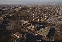
Aerial view of Kansas City
-
Aerial view of Kansas City above the intersection of Interstates 35 and 670 looking west. Several parking lots and empty lots are below the intersection. The Convention Center is on the far right., 1984, Digitizing agency: University of Missouri--Kansas City. Library. Dr. Kenneth J. LaBudde Special Collections., "Copyright '84 / Bob Barrett" is printed on slide mount.
-
-
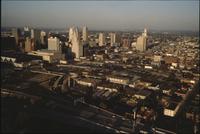
Aerial view of Kansas City
-
Aerial view of Kansas City above Interstate 670 looking west. The sun is setting and casting a glare on the photo. Skyscrapers and downtown Kansas City are on the right. Houses and office buildings are spread to the left., 1984, Digitizing agency: University of Missouri--Kansas City. Library. Dr. Kenneth J. LaBudde Special Collections., "Copyright '84 / Bob Barrett" is printed on slide mount.
-
-
Aerial view of Kansas City
-
Aerial view of Kansas City above the intersection of Interstates 35 and 670 looking west. Several parking lots and empty lots are below the intersection. The Convention Center is on the far right., 1984, Digitizing agency: University of Missouri--Kansas City. Library. Dr. Kenneth J. LaBudde Special Collections., "Copyright '84 / Bob Barrett" is printed on slide mount.
-
-
Aerial view of Kansas City
-
Aerial view of Kansas City looking northeast toward downtown. Interstate 35 is passing north over Interstate 670. The Missouri River is visible in the distance on the left. The Convention Center is on the left with a dark, flat roof. To the right is the Municipal Auditorium. To the right of the auditorium is the Kansas City Power and Light Building. There are office buildings and houses spread below the highways., 1984, Digitizing agency: University of Missouri--Kansas City. Library. Dr. Kenneth J. LaBudde Special Collections., "Copyright '84 / Bob Barrett" is printed on slide mount.
-
-
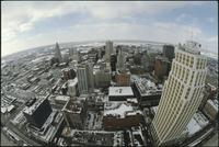
Aerial view of Kansas City
-
Aerial view of Kansas City looking east from a downtown skyscraper. Several parking lots are in front. Cars are driving along the roads. One skyscraper is on the left. All the buildings and lots are covered with a light layer of snow. Clouds passing overhead are casting shadows., 1985, Digitizing agency: University of Missouri--Kansas City. Library. Dr. Kenneth J. LaBudde Special Collections., "Copyright '85 / Bob Barrett" printed on slide mount.
-
-
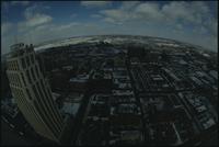
Aerial view of Kansas City
-
Aerial view of Kansas City looking northeast from a downtown skyscraper. Several parking lots are in front. Cars are driving along the roads. A white skyscraper is in the front and several more are farther back. All the buildings and lots are covered with a light layer of snow., 1985, Digitizing agency: University of Missouri--Kansas City. Library. Dr. Kenneth J. LaBudde Special Collections., "Copyright '85 / Bob Barrett" printed on slide mount.
Pages