Robert F. Barrett Collection
Pages
-
-
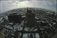
Aerial view of Kansas City
-
Aerial view of Kansas City looking northeast from a downtown skyscraper. Several parking lots are in front. Cars are driving along the roads. A white skyscraper is in the front and several more are farther back. All the buildings and lots are covered with a light layer of snow., 1985, Digitizing agency: University of Missouri--Kansas City. Library. Dr. Kenneth J. LaBudde Special Collections., "Copyright '85 / Bob Barrett" printed on slide mount.
-

-
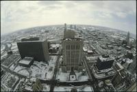
Aerial view of Kansas City
-
Aerial view of Kansas City looking north from atop the Power & Light building. Several parking lots are on the right. Cars are driving along the roads. There are dozens of skyscrapers and office buildings. The Missouri River is visible in the distance. Clouds passing overhead are casting shadows on the buildings., June 1983, Digitizing agency: University of Missouri--Kansas City. Library. Dr. Kenneth J. LaBudde Special Collections., Slide mount is captioned "Kansas City, Mo. (Historical) View to the South--June '83 atop power & Light Bldg."
-

-
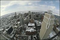
Aerial view of Kansas City
-
Aerial view of Kansas City from atop a building in downtown. Several skyscrapers are scattered between office buildings and parking lots. Cars are driving along the roads. All the buildings and lots are covered with a light layer of snow., 1985, Digitizing agency: University of Missouri--Kansas City. Library. Dr. Kenneth J. LaBudde Special Collections., "Copyright '85 / Bob Barrett" printed on slide mount.
-

-
Aerial view of Kansas City
-
Aerial view of Kansas City looking east from a downtown skyscraper. Several parking lots are in front. Cars are driving along the roads. One skyscraper is on the left. All the buildings and lots are covered with a light layer of snow., 1985, Digitizing agency: University of Missouri--Kansas City. Library. Dr. Kenneth J. LaBudde Special Collections., "Copyright '85 / Bob Barrett" printed on slide mount.
-

-
Aerial view of Kansas City
-
Aerial view of Kansas City looking northeast from atop the Power & Light building. Several parking lots are in the foreground. Cars are driving along the roads. There are dozens of skyscrapers and office buildings. The Missouri River is visible in the distance., June 1983, Digitizing agency: University of Missouri--Kansas City. Library. Dr. Kenneth J. LaBudde Special Collections., Slide mount is captioned "Kansas City, Mo. (Historical) View to the South--June '83 atop power & Light Bldg."
-

-
Aerial view of Kansas City
-
Aerial view of Kansas City looking north from atop the Power & Light building. Several parking lots are on the right. Cars are driving along the roads. There are dozens of skyscrapers and office buildings. The Missouri River is visible in the distance., June 1983, Digitizing agency: University of Missouri--Kansas City. Library. Dr. Kenneth J. LaBudde Special Collections., Slide mount is captioned "Kansas City, Mo. (Historical) View to the South--June '83 atop power & Light Bldg."
-
-
Aerial view of Kansas City
-
Aerial view of Kansas City looking south, likely from City Hall building. The Bolling Federal building is on the left. The Jackson County Courthouse is in the center. Interstate 670 is behind the buildings and an interchange with highway 71 is on the left. All the buildings and lots are covered with a light layer of snow., 1985, Digitizing agency: University of Missouri--Kansas City. Library. Dr. Kenneth J. LaBudde Special Collections., "Copyright '85 / Bob Barrett" printed on slide mount.
-

-
Aerial view of Kansas City
-
Aerial view of Kansas City looking south, likely from City Hall building. The Jackson County Courthouse is on the left. Dozens of other skyscrapers and office buildings are on the right. Interstate 670 is behind the buildings. All the buildings and lots are covered with a light layer of snow., 1985, Digitizing agency: University of Missouri--Kansas City. Library. Dr. Kenneth J. LaBudde Special Collections., "Copyright '85 / Bob Barrett" printed on slide mount.
-
-
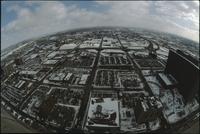
Aerial view of Kansas City
-
Aerial view of Kansas City looking south from atop a building in downtown. Several large office buildings are scattered between large parking lots. Interstate 670 passed over and under roads several blocks away. All the buildings and lots are covered with a light layer of snow., 1985, Digitizing agency: University of Missouri--Kansas City. Library. Dr. Kenneth J. LaBudde Special Collections., "Copyright '85 / Bob Barrett" printed on slide mount.
-
-
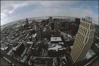
Aerial view of Kansas City
-
Aerial view of Kansas City looking northeast from a downtown skyscraper. Several parking lots are in front. Cars are driving along the roads. A white skyscraper is in the front and several more are farther back. All the buildings and lots are covered with a light layer of snow. Clouds passing overhead are casting shadows., 1985, Digitizing agency: University of Missouri--Kansas City. Library. Dr. Kenneth J. LaBudde Special Collections., "Copyright '85 / Bob Barrett" printed on slide mount.
-

-
Aerial view of Kansas City
-
Aerial view of Kansas City looking north from atop the Power & Light building. Several parking lots are on the right. Cars are driving along the roads. There are dozens of skyscrapers and office buildings. The Missouri River is visible in the distance., June 1983, Digitizing agency: University of Missouri--Kansas City. Library. Dr. Kenneth J. LaBudde Special Collections., Slide mount is captioned "Kansas City, Mo. (Historical) View to the South--June '83 atop power & Light Bldg."
-

-
Aerial view of Kansas City
-
Aerial view of Kansas City looking south from atop a building in downtown. Several large office buildings are scattered between large parking lots. Interstate 670 passed over and under roads several blocks away. All the buildings and lots are covered with a light layer of snow., 1985, Digitizing agency: University of Missouri--Kansas City. Library. Dr. Kenneth J. LaBudde Special Collections., "Copyright '85 / Bob Barrett" printed on slide mount.
-
-
Aerial view of Kansas City
-
Aerial view of Kansas City looking south, likely from City Hall building. The Bolling Federal building is on the left. The Jackson County Courthouse is in the center. Interstate 670 is behind the buildings and an interchange with highway 71 is on the left. All the buildings and lots are covered with a light layer of snow., 1985, Digitizing agency: University of Missouri--Kansas City. Library. Dr. Kenneth J. LaBudde Special Collections., "Copyright '85 / Bob Barrett" printed on slide mount.
-

-
Aerial view of Kansas City
-
Aerial view of Kansas City above land under development looking south. The Missouri River is passing under a small bridge on the left. Downtown Kansas City is visible in the distance. The area in the foreground is covered in dirt and is surrounded by trees., June 1986, Digitizing agency: University of Missouri--Kansas City. Library. Dr. Kenneth J. LaBudde Special Collections., Slide mount is captioned "Kansas City: Aerials Skyline." "LXXXVI Bob Barrett" is printed on slide mount.
-

-
Aerial view of Kansas City
-
Aerial view of Kansas City from the north. There are open fields and warehouses in the foreground. The Missouri River and downtown Kansas City are in the distance., June 1986, Digitizing agency: University of Missouri--Kansas City. Library. Dr. Kenneth J. LaBudde Special Collections., Slide mount is captioned "Kansas City: Aerials Skyline." "LXXXVI Bob Barrett" is printed on slide mount.
-

-
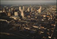
Aerial view of Kansas City
-
Aerial view of Kansas City looking northeast toward downtown. Interstate 35 is passing north over Interstate 670. The Missouri River is visible in the distance on the left. The Convention Center is on the left with a dark, flat roof. To the right is the Municipal Auditorium. To the right of the auditorium is the Kansas City Power and Light Building. There are office buildings and houses spread below the highways., 1984, Digitizing agency: University of Missouri--Kansas City. Library. Dr. Kenneth J. LaBudde Special Collections., "Copyright '84 / Bob Barrett" is printed on slide mount.
-
-
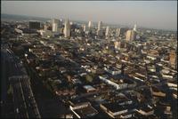
Aerial view of Kansas City
-
Aerial view of Kansas City above Interstates 35 and 670 looking northeast. Skyscrapers, parking lots, and downtown Kansas City are visible across from the highway. The Convention Center, Municipal Auditorium, and Kansas City Power and Light Building are on the left. The sun is setting and casting large shadows on the buildings., 1984, Digitizing agency: University of Missouri--Kansas City. Library. Dr. Kenneth J. LaBudde Special Collections., "Copyright '84 / Bob Barrett" is printed on slide mount.
-
-
Aerial view of Kansas City
-
Aerial view of Kansas City above Interstate 35 looking northeast. Skyscrapers, parking lots, and downtown Kansas City are visible in the center. There are office buildings and houses spread to the right. The Missouri River is in the far distance., 1984, Digitizing agency: University of Missouri--Kansas City. Library. Dr. Kenneth J. LaBudde Special Collections., "Copyright '84 / Bob Barrett" is printed on slide mount.
-

-
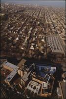
Aerial view of Kansas City
-
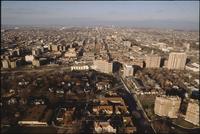
Aerial view of Rockhill, Manheim Park, and Ivanhoe neighborhoods in Kansas City. Volker Boulevard and Brush Creek pass through the middle of the photo. The Menorah Medical Center and University of Missouri-Kansas City are in the bottom left. The Nelson-Atkins Museum of Art is on the left at the end of a long green lawn. Troost Avenue is in the center running north and south. Downtown Kansas City and the Missouri River are in the distance., December 22, 1984, Digitizing agency: University of Missouri--Kansas City. Library. Dr. Kenneth J. LaBudde Special Collections., "Copyright '84 / Bob Barrett" is printed on slide mount.
-

-
Aerial view of Kansas City
-
Aerial view of Rockhill, Manheim Park, and Ivanhoe neighborhoods in Kansas City. Volker Boulevard and Brush Creek pass through the middle of the photo. The Menorah Medical Center and University of Missouri-Kansas City are in the bottom left. The Nelson-Atkins Museum of Art is on the left at the end of a long green lawn. Troost Avenue is in the center running north and south. Downtown Kansas City and the Missouri River are in the distance., December 22, 1984, Digitizing agency: University of Missouri--Kansas City. Library. Dr. Kenneth J. LaBudde Special Collections., "Copyright '84 / Bob Barrett" is printed on slide mount.
-

-
Aerial view of Manheim neighborhood
-
Aerial view of the Manheim neighborhood in Kansas City near Volker Boulevard, Troost Avenue, and Paseo Boulevard. Troost and Paseo are running north and south near the center of the photo. There are parking lots surrounding the University of Missouri-Kansas City building for KCUR radio station. There are houses throughout the area., December 22, 1984, Digitizing agency: University of Missouri--Kansas City. Library. Dr. Kenneth J. LaBudde Special Collections., "Copyright '84 / Bob Barrett" is printed on slide mount.
-
-
Aerial view of Menorah Medical Center
-
Aerial view of Menorah Medical Center and other buildings along Brush Creek in Kansas City. Menorah Medical Center is at the bottom in-between Rockhill Road and Volker Boulevard. Downtown Kansas City is in the distance., December 22, 1984, Digitizing agency: University of Missouri--Kansas City. Library. Dr. Kenneth J. LaBudde Special Collections., "Copyright '84 / Bob Barrett" is printed on slide mount.
-

-
Aerial view of Menorah Medical Center and the Nelson-Atkins Art Museum
-
Aerial view of Menorah Medical Center and other buildings along Brush Creek in Kansas City. Menorah Medical Center is at the bottom right in-between Rockhill Road and Volker Boulevard. The Nelson-Atkins art museum is on edge of a green lawn on the left. Downtown Kansas City is in the distance., December 22, 1984, Digitizing agency: University of Missouri--Kansas City. Library. Dr. Kenneth J. LaBudde Special Collections., "Bob Barrett" is printed on slide mount.
-

-
Aerial view of Nelson-Atkins lawn
-
Aerial view the front lawn of the Nelson-Atkins Museum of Art in Kansas City looking south. The lawn ends at Brush Creek and Volker Boulevard. The campus for University of Missouri-Kansas City is on the other side of the road. Menorah Medical Center and the UMKC library are in the center further up. The lawn is surrounded by houses and parking lots., December 22, 1984, Digitizing agency: University of Missouri--Kansas City. Library. Dr. Kenneth J. LaBudde Special Collections., "Copyright '84 / Bob Barrett" is printed on slide mount.
-
-
Aerial view of Plaza region
-
Aerial view the Country Club Plaza region in Kansas City looking north. The Intercontinental hotel is in the center overlooking Brush Creek at the intersection of Volker Boulevard and Wornall Road. There are houses and apartment buildings below the hotel. Skyscrapers and downtown Kansas City are visible in the distance., December 22, 1984, Digitizing agency: University of Missouri--Kansas City. Library. Dr. Kenneth J. LaBudde Special Collections., "Copyright '84 / Bob Barrett" is printed on slide mount.
-

-
Aerial view of UMKC
-
Aerial view of Pierson Auditorium at the University of Missouri-Kansas City. The auditorium is in a building at the bottom of the photo near a parking circle. There are parking lots and other university buildings near the auditorium. Rockhill Road, Volker Boulevard, and Brush Creek pass through the trees halfway up the photo. The Nelson-Atkins museum is on the left at the edge of a long green lawn. Skyscrapers and downtown Kansas City are in the distance., December 22, 1984, Digitizing agency: University of Missouri--Kansas City. Library. Dr. Kenneth J. LaBudde Special Collections., "Copyright '84 / Bob Barrett" is printed on slide mount.
-

-
Aerial view of Union Hill
-
Aerial view of the Union Hill neighborhood in Kansas City. A large radio antenna is in the center near several office buildings. There are houses throughout the neighborhood., September 1974, Digitizing agency: University of Missouri--Kansas City. Library. Dr. Kenneth J. LaBudde Special Collections., "Bob Barrett" is printed on slide mount.
Pages