Maps
Pages
-
-
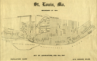
St. Louis, Mo.: Boundary of 1841
-
Reproduction map by Norbury Wayman showing the boundaries of the City of Saint Louis in 1841. Population 16,469; 4.78 Square Miles.
-
-
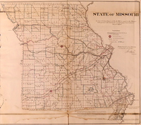
State of Missouri
-
"See Jos. S. Wilson's report of March 1866 in regard to the Missouri titles printed with documents accompanying Commissioner's Annual Report." This map of the state of Missouri shows counties, cities, rivers, copper and iron mines, seat of land offices, and county seats. It also shows land grant railroads with the 6 and 15 mile limits of their grants. "Note: Iron Mountain (Iron Co.) is composed exclusively of Iron ore in its purest form. The height of this mountain is 228 feet, and its base covers an area of 500 acres, which is calculated to give 1,655,280,000 cubic feet, or 230,187,375 tons of ore. There are several other Mountains in this region, and it is computed that there is iron ore enough in Missouri to furnish 1,000,000 tons per annum of manufactured iron for the next two hundred years. Sir S. Morton Peto.", Mapping St. Louis Catalog 32b
-
-
Steamboat Wharf Locations at St. Louis
-
This map, plotted out by Norbury Wayman, shows the various locations of steamboat lines and related companies on the St. Louis levee, detailing three periods of time; before 1865; 1865 - 1900; and 1900 - 1953. Lines and companies are donated by name, location and years of operation. Nearby streets are mapped as well, for easy frame of reference. Scale in feet: 100 ft. = 1 inch.
-
-
Street Car Movements
-
United Railways evening peak schedule, number of cars in 30 minute period, downtown business district. From the Report on Rapid Transit to the St. Louis Board of Aldermen, 1926., Report on rapid transit for St. Louis / Kinsey, president, Board of Public Service, C. E. Smith, Consulting Engineer ; submitted to the Board of Aldermen, September, 1926.
-
-
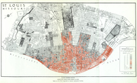
Substandard Dwelling Unites
-
Plate number seven. Obsolete dwellings breed slums. Slums are the direct outgrowth of obsolete substandard housing., From: Report / City Plan Commission of St. Louis. [St. Louis] : City Plan Commission of St. Louis. 1942.
-
-
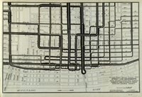
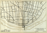
Surface Car Subways With Rerouted Car Lines
-
Map of surface car subways with rerouted car lines from 1925. From a Report to the Board of Alderman from 1926., Report on rapid transit for St. Louis / Kinsey, president, Board of Public Service, C. E. Smith, Consulting Engineer ; submitted to the Board of Aldermen, September, 1926.
-

-
The "Father of Waters"
-
This facsimile of William Glazier's "The 'Father of Waters'" shows the Mississippi River from Glazier's believed source - Lake Glazier, to the Gulf of Mexico. The original map was produced by Glazier in 1887.
-
-
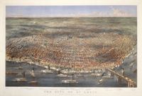
The City of St. Louis
-
In the 1870s the great American tradition of bird's eye views became a popular way of depicting the seemingly limitless potential and growth of the great American cities. St. Louis was no exception and several documented the city's prominence in this period. Bird's eye view of the city of St. Louis from the waterfront stretching west. Important places are listed at the bottom of the view: Carondelet, Shaw's Botanical Garden, Compton Hill Reservoir, Market, Insane Asylum, Gas House, R. C. Convent, St. Louis & Iron Mt. R.R. Depot, Pacific and Missouri R.R. Depots, City Hall (Four Courts), St. James Hotel, Southern Hotel, Washington Sq., Masonic Temple, Jewish Synagogue, Laclede Hotel, Court House, Planters House, New Post Office, Missouri Republican Bldg., Missouri Park, New Post Office, St. Louis University, Odd Fellows Hall, St. Louis Life Ins Co, Union Market, New Reservoir, Mississippi Bridge, Fair Grounds, Hyde Park, St. Louis Kansas & Northern R.R., Elevator, Northern Park, Water Works. Many steamboats and much commerce can be seen in the foreground., Statement of responsibility: Sketched & Drawn on Stone by Parsons & Atwater.
-
-
The City of St. Louis Missouri.
-
Despite the tagline, "Entered according to Act of Congress in the Year 1855 by J. H. Colton & Co. in the Clerks Office of the District Court of the United States for the Southern District of New York." this map seems to be an updated version of Colton's 1855 map that appeared in an 1872 atlas.
-

-
The Saint Louis Common Fields
-
In the 1830’s seemingly everyone wanted a print or view of the new town or a map of property; Eugene Dupre was an entrepreneur, first coming to St. Louis as s tailor, next a lithographer and mapmaker in these busy days for the city.
-
-
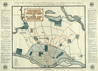
Tourist's Trolley Map of St. Louis and Environs
-
During 1915 the United Railways transported 356,814,595 passengers - of these 124,043,205 were free transfer passengers. The average fare per passenger therefore was 3.23 cents. The ratio of fatalities in 1915 was one fatality to 89 million Passengers. A STREET CAR IS A PRETTY SAFE PLACE.
-

-
Transportation Map of Missouri
-
Map delineates rail lines throughout the state of Missouri., St. Louis: The Missouri Commission, Louisiana Purchase Exposition, 1904
-

-
United States.
-
The map of the United States is from T. G. Bradford’s "A Comprehensive Atlas Geographical" (Boston: Wilkins and Carter, 1843).
Pages