Maps
Pages
-
-
Course of the River Mississippi, from the Balise to Fort Chartres
-
Based on surveys conducted only a few years after the Treaty of Paris ceded lands east of the Mississippi to England, Lieutenant Ross’s detailed map was a significant advance over such distinguished French cartographers as D’Anville. On a scale like few others for the length of river depicted, the Ross map was widely held to be the most reliable map of the river produced in the 18th century—it clearly evidences the Mississippi Valley’s growing social, political, commercial and agricultural significance., Details Mississippi River in 1765. Published in 1778 edition of: The American atlas : or, A geographical description of the whole continent of America: wherein are delineated at large, its several regions, countries, states, and islands ; and chiefly the British colonies, composed from numerous surveys / several of which were made by order of government by Major Holland ... [et al.] ; engraved on 49 copper-plates by Thomas Jefferys and others.
-

-
Crown Point
-
This Elegant Suburban Residence Property is located on one of the highest points in the county, affording a magnificent view of the surrounding country.
It overlooks and adjoins three gems of suburban places, Old Orchard, Tuxedo and Webster Parks. The streets are made.
The New Double Track of the Southwestern Extension of the Suburban Line to Old Orchard and Webster will take you to these elegant lots for 10 cts. and the cars on the Missouri Pacific and Frisco Line for only 8 cts. The lots are offered at extremely low prices and on easy terms.
For full information and plats apply to Adam Boeck & Co., Agents, 622 Chestnut Street. 'Phone No. 894.
-

-
Diagram of the State of Missouri
-
Map of the townships of the State of Missouri in 1849. Map by F. R. Conway, surveyor of the public lands in the States of Missouri and Illinois. This map includes different boundary lines, including the old Indian boundary line, the old west boundary line, and the 1837 northern boundary lines.
-

-
Diagram of the State of Missouri
-
Map shows the townships of Missouri according to the Surveyors Office at St. Louis on the 30th of October 1837. The map also illustrates some of the different boundaries of the State of Missouri. Drawn to a scale of 18 miles to an inch.
-

-
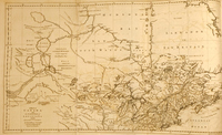
Draught of the River Missis[s]ippi from the Balise up to Fort Chartres
-
This is the most important description of old and new settlements along the Mississippi River Valley in English in the 18th century by a soldier who volunteered to bring new knowledge to the British command in North America concerning Louisiana, all readers having to the time of publication of this new book depended far too long on out of date sources. Pittman himself had noted that “Louisiana is no longer the same as in the time of Pere Hennepin, and all other authors that I have read on this subject rather abound with Indian stories and talks, than with useful information”. He was in St. Louis two years after its establishment and observed its progress directly. He mapped the region thoroughly for his government as Ross had done, to Fort Chartres., From: The present state of the European settlements on the Mississippi : with a geographical description of that river illustrated by plans and draughts / by Captain Philip Pittman.
-

-
Estados Unidos de la America Septentrional
-
An early European map showing the origin of all the major rivers in one high elevation, still strongly viewed as a possibility in the unexplored territories. The young United States, including Missouri and Arkansas, are outlined in yellow—“Missiri” is the territorial name, “Sn. Luis” is the name used for the state of Missouri. The Pacific Northwest is outlined in blue as “Colombia” and, again, most of the Louisiana Territory, as “Missiri, in red. By Pablo Alabern i Moles.
-

-
Fracl. Township 45 N. R. 7E.
-
Hutawa came to St. Louis from eastern Europe in the early 1830’s with family members and settled in St. Louis, a home base for a lithography business which lasted for many years and which specialized in maps—some of the very first west of the Mississippi for an American city of any kind—and of the American west. See also Fracl. Township 45 N. R. 7E.: Confirmed Claims., Atlas of the County of St. Louis, Missouri by Congressional Townships compiled by Edward Hutawa. (St. Louis: Hutawa, 1848)
-

-
Fracl. Township 45 N. R. 7E.
-
Hutawa came to St. Louis from eastern Europe in the early 1830’s with family members and settled in St. Louis, a home base for a lithography business which lasted for many years and which specialized in maps—some of the very first west of the Mississippi for an American city of any kind—and of the American west. See also Fracl. Township 45 N. R. 7E.: Map., Atlas of the County of St. Louis, Missouri by Congressional Townships compiled by Edward Hutawa. (St. Louis: Hutawa, 1848)
-
-
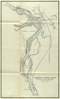
Harbor of Saint Louis.
-
Map of the Mississippi River stretching from Alton, Illinois to Saint Louis, Missouri and East Saint Louis, Illinois. Includes islands (Kerr's Island; Cabaret Island; Chouteau Island; Wilson's Island; Mobile Island; Ellis Island) and railroads (CH. A. & ST. L. R. R.; St. L. A. & T. H. R. R.; Edwardsville Coal R. R.; O. & M. R. R.)., From: Message of the mayor, and reports of city officers : delivered to the city council.
-

-
Hemisphere occidental
-
A work of geo-politics by De l’Isle and presented by his Amsterdam publishers — showing the French lands in the context of a still relatively unexplored and unverified northwestern continent.
-

-
Il Paese de’ Cherachesi, con la Parte Occidentale della Carolina Setenttrionale, e della Virginia
-
This map and the atlas it which it appeared were based on the important map by John Mitchell, one of the earliest English mapmakers to give an accurate representation of the Missouri and the central river system of the mid continent. Mitchell’s maps were influential for a century and, as seen here, were appreciated by an international following of mapmakers., From Le Colonie Unite dell’ America Settentrionale.
-

-
Johnson's Missouri and Kansas
-
Map of Missouri and Kansas, as well as portions of Iowa, Arkansas, and Illinois. Detailed map of counties and places, as well as roads. Includes insets titled: "Spearing fish", "Santa Fe from the Great Missouri Trail", and "Fire on the prairie.", From Johnson's new illustrated (steel plate) family atlas : with physical geography and with descriptions geographical, statistical and historical, including the latest federal census, a geographical index, and a chronological history of the Civil War in America / by Richard Swainson Fisher ... ; maps compiled and drawn, and engraved under the supervision of J.H. Colton and A.J. Johnson.
-

-
Lovisiana by de Rivier Missisippi.
-
Map of the river system from the Dutch edition of John Law’s own description of Louisiana’s great prospects, the Mississippi Bubble. The map covers and area from the Mississippi River's mouth, north to Canada. It was immensely important in creating awareness of the faraway region, a remote wilderness., Map from John Law's "Het groote Tafereel der Dwaasheid : vertoonende de opkomst, voortgang en ondergang der Actie, Bubbel en Windnegotie, in Vrankryk, Engeland, en de Nederlanden, gepleegt in dem Jaare 1720", a collection of various pieces on the South Sea Bubble in prose and verse, with a number of caricatures, brought together under a general titlepage.
-

-
Map Showing the Disputed Boundary of Missouri and Iowa
-
This map depicts the steps officials in Missouri and Iowa took to create two modern states. They were landmarks in their day - actually led to possible armed conflict in the "Honey War" on the contested state line or lines, when several honey bee tree hives were cut down - militias and hot heads assembled on both sides of the supposed boundaries. Iowa got a proper line and eventually Missouri got the Platte district and stretched towards Council Bluffs and the Missouri River country's rich soil in the northwest. Much of the work for the resolution of this conflict was performed out of St. Louis in the 1830s.
Shows four claim lines: No. 1 and No. 2: old Indian boundary or Sullivan's Line; No. 3; and No. 4: Brown's Line or line claimed by Missouri. Longitude west from Washington. Executed under the direction of the Commissioner on the part of the United States. January 1839, signed by Albert Miller Sea, Court for U. States.
-

-
Map and View of St. Louis
-
Drawn, engraved & printed by J. M. Kershaw, 34 Second St. St. Louis. Kershaw’s plans shows in the border the great building occurring in St. Louis in the 1840’s, truly a frontier metropolis in the making., The St. Louis directory for 1848 : containing the names of the inhabitants, their occupations, places of business, and dwelling houses ... / by J.H. Sloss.
-

-
Map of Saint Louis
-
This 1898 map of the City of Saint Louis was created by the City Lighting Department.
-

-
Map of Sewer Districts
-
Map of City of St. Louis. Sewer design section. Office of the President - Board of Public Service.
-

-
Map of the Bounty Lands of the Illinois Territory
-
This map was produced by Gardiner as Chief Clerk of the General Land Office of the United States under pressure by Congress to begin the sale of "bounty lands" cheaply to veterans of past wars in recognition of military service rendered. This map was signed by Gardiner in distributing, verifying and describing a new settler's plot: "Description of the SE of section 35 in township 4N of range 7 West. A stream in the quarter section, part gently rolling woodland and good soil, part level, Rich prairie; Timber Oak & Hickory underwood, Hazel. Your lot is black in the yellow township."
-

-
Map of the City of St. Louis, Mo.
-
Edward and Julius Hutawa's map of the city of Saint Louis in 1846. Contains numbered local landmarks., The Western metropolis : or St. Louis in 1846 / compiled by W.D. Skillman.
-

-
Map of the Country of the Illinois
-
Collot’s maps of Louisiana were made in 1796 and were most likely planned for military intrigues and colonial conquest, but the work transcended its purpose in thoroughly documenting the earliest settlements of the Illinois Country. These plans were the most detailed to their time., From Collot's work "Voyages dans l'Amérique Septentrionale, ou Description des pays arrosés par le Mississippi, l'Ohio, le Missouri et autres rivières affluentes..." Published in Paris by A. Bertrand, 1826.
-

-
Map of the Eighth Federal Reserve District
-
St. Louis, the metropolis of the district is the home of the Mercantile Trust Company and Mercantile National Bank, both members of the Federal Reserve Bank system. The combined deposits of these two institutions aggregate $32,169,674.84., Statement of responsibility: The Federal Reserve Bank with special reference to District No. 8 : the resources and chief products of the district / compiled and issued by Mercantile Trust Company and Mercantile National Bank.
Pages